



Maps and SUMO Assets
Use map assets from sumo/assets/maps/ when they already match your CARLA
map. This page covers generating a new road network and polygons, and
inspecting coordinates for scenario YAML files.
Prepare the Conversion Environment
Run the helper scripts from the OpenCDA repository root in a Python
environment with CARLA 0.9.16, lxml and sumolib. Network generation additionally
needs the SUMO distribution (including netconvert and its tools).
The OpenCDA container does not install the SUMO executable by default.
For a temporary conversion environment in the OpenCDA container:
python -m venv --system-site-packages /tmp/cavise-map-tools
source /tmp/cavise-map-tools/bin/activate
python -m pip install eclipse-sumo==1.27.0
export SUMO_HOME="$(python -c 'import sumo; print(sumo.SUMO_HOME)')"
export PATH="$SUMO_HOME/bin:$PATH"
netconvert --version
The temporary environment is lost when the container is recreated. The
commands below save assets into opencda/sumo-assets/, which Compose mounts
from the host’s sumo/assets/ directory. Set CARLA_HOST as described in
Connect from OpenCDA. Keep CARLA running without an active OpenCDA scenario
while converting maps, because the conversion tools can load maps and tick
the world.
Generate a Road Network
In the same OpenCDA container shell:
mkdir -p opencda/sumo-assets/maps/Town06
python scripts/netconvert_carla.py --from-carla \
  --carla-host "$CARLA_HOST" --carla-map Town06 \
  --output opencda/sumo-assets/maps/Town06/Town06.generated.net.xml
The distinct .generated filename lets you inspect the result before
replacing existing assets. Alternatively pass a local .xodr file instead
of --from-carla. See Utility Scripts for script options.
Inspect lane connectivity and traffic lights in SUMO/netedit before using the network in an experiment. Generate routes against this network’s edge IDs.
Generate Polygons
Use the generated network for coordinate conversion and clipping:
python scripts/polyconvert_carla.py \
  --net-file opencda/sumo-assets/maps/Town06/Town06.generated.net.xml \
  --output opencda/sumo-assets/maps/Town06/Town06.generated.poly.xml \
  --carla-host "$CARLA_HOST" --carla-map Town06
Reference the chosen polygon file in your scenario’s .sumocfg:
<additional-files value="../maps/Town06/Town06.generated.poly.xml"/>
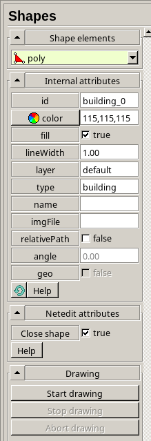
For manual corrections, open the scenario in netedit and switch to Polygon Mode. Enable fill and a closed shape, set its ID/type, draw the vertices, then save. The example toolbar and polygon settings are shown below.

Get Scenario Coordinates
Use the CARLA spectator to locate a road position. From the OpenCDA container shell:
python scripts/get_spectator_position.py --carla-host "$CARLA_HOST"
To move the spectator:
echo "10.0,20.0,50.0" | python scripts/set_spectator_position.py \
  --carla-host "$CARLA_HOST"
The printed transform is the camera position. Adapt it to a valid vehicle spawn point on the road. Do not copy the camera altitude into a vehicle’s spawn height. Check the YAML pose convention used by your chosen scenario.